3 Cutting-Edge Satellite Technologies Showcase Nature’s Impact on Water
This article was originally posted on WRI Insights.
In Costa Rica, climate change is intensifying the Reventazón basin’s susceptibility to flooding and contamination. This is concerning given that the basin is pivotal for supplying 25% of the drinking water surrounding Costa Rica’s capital of San José, irrigating 85% of the nation’s vegetable production and generating 38% of its main energy source via hydropower.
But government officials now have a powerful tool to monitor and help fight against the natural causes threatening Costa Rica’s people and infrastructure: satellites. From above, satellites can comprehensively monitor entire river systems and basins. Researchers can get data as quickly as three hours after capture — allowing for quick analyses and decision-making from water managers. Satellite archives also provide researchers with historical data that includes major flooding events. These advantages are all accompanied by lower equipment, maintenance and labor costs.
This is especially important as nature-based solutions begin to be used to mitigate climate impacts and protect local communities. These approaches restore or conserve natural resources for a variety of social, economic and environmental benefits. For example, a nature-based solution could include protecting a forest to improve water filtration and reduce water treatment costs.
Unlike traditional built infrastructure and technologies, nature-based solutions have not benefited from hundreds of years of development, testing and studies. Therefore, efficient and low-cost methods for monitoring progress are necessary as scores of questions and concerns over long-term benefits remain.
For water projects that aim to improve water supply or quality, like those in Costa Rica, this evidence is especially difficult to gather, since benefits may take multiple years due to the complexities of the average water cycle.
At present, satellites have some shortcomings and can be an imperfect solution for monitoring water. For example, satellites often can’t see through murky water, which limits the ability to measure water depth. But there are initiatives using satellite observation that are working to make monitoring water less complex. As nature-based solution projects become more commonly monitored through satellite technologies, uncertainties in the outcomes of those projects will be reduced over time for project developers, funders and investors.
Here are three of these cutting-edge initiatives.
1. Planet’s Commercial Nanosatellites: SkySat and PlanetScope Dove
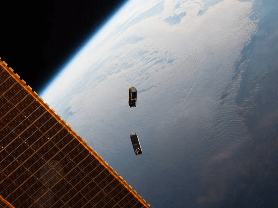
Satellites that track river flows over time provide information on whether efforts to protect or restore watersheds are improving water supply for downstream communities or hydropower facilities. Planet, a leading commercialized provider of global satellite imagery, owns SkySat and PlanetScope, which are constellations of nanosatellites that can be the size of a minifridge or a shoebox and contain very high resolutions. These nanosatellites take images of every spot on Earth multiple times a day, as opposed to traditional satellites that take one image every few days.
PlanetScope’s more than 120 satellites allow measurements of water clarity, known as turbidity, in small ponds and narrow coves of reservoirs.
This year, SkySat’s 21 satellites have allowed a team at the United Kingdom Center of Ecology and Hydrology to be the first to measure river flows solely from space, saving them from intensive fieldwork and multiple drone deployments.
Because the data is commercialized, projects would have to pay for access unless they are eligible to join a program such as ESA’s Earthnet, which has limited membership. Conversely, the uniquely high resolution of Planet’s satellites would allow for space observations of streamflow before and after implementation of nature-based solutions, which could save tens of thousands of dollars in equipment and maintenance fees and expand access to water discharge measurements in secluded locations.
Planet’s satellites can be used for sectors outside of water, including agriculture, energy and infrastructure, forestry, land, disaster response and climate monitoring.
2. OpenET
Satellites can help capture changes in a forest’s water balance or how rainfall refills underground water supply by analyzing data measuring evapotranspiration, or the process in which water is released into the atmosphere from plants, soil and other surfaces. Scientists input satellite data and various weather-related parameters, such as temperature and wind speed, into computer models to create single estimates of evapotranspiration.
OpenET is a public-private collaboration that uses satellite data from NASA and the U.S. Geological Survey to provide accessible and free information on evapotranspiration. This data is helpful in the water and forestry sectors and can be applied through an agricultural lens to track reductions in irrigation and electricity consumption. For example, the Salt River Project in Arizona has used OpenET to understand how forest management, such as prescribed controlled burns and thinning, changes water balances. Projects using nature-based solutions could similarly use OpenET to understand how their implementations regulate the hydrological cycle through streamflow and underground water replenishment.
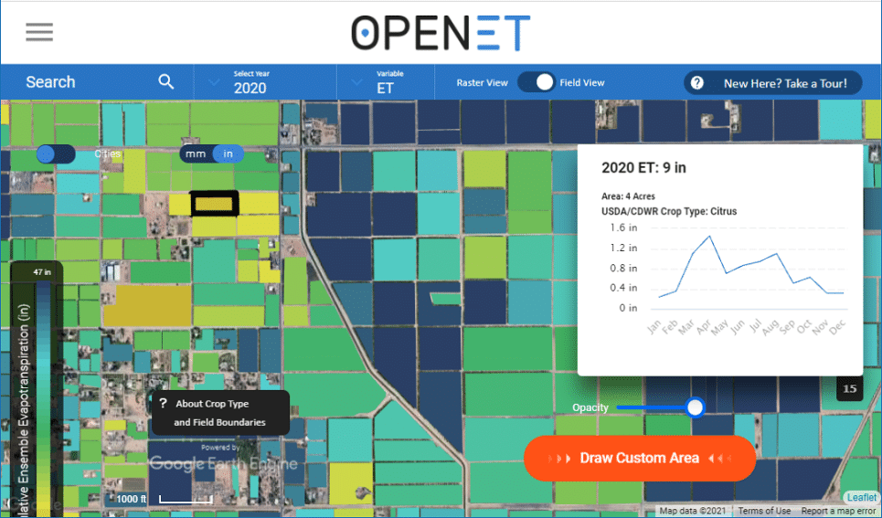
OpenET is currently putting monthly data sets and select historical data on Google Earth and will soon be releasing a platform that aims for user-friendliness, free for access by nonprofits.
3. Gybe
Many nature-based projects aim to enhance drinking water quality by using reforestation as an erosion control measure, which reduces the amount of sediment in water supply systems. These projects need a reliable way to track how forest management and sustainable agriculture reduce sediment and other contaminants in streams.
Gybe, a software-as-a-service technology company, offers a tool (GybeMaps) that turns satellite data into turbidity, sediment and other water quality information catered toward individual projects. Projects that subscribe to Gybe will receive automatically-processed data rather than having to hire analysts, significantly lowering staffing costs. The Nature Conservancy has used Gybe to understand the fluctuation of sediment levels near hydropower facilities in their Rio de Janeiro, Cuenca Verde and the Upper Tana-Nairobi Water Fund projects.
The Future of Satellites for Water Monitoring
Using satellite observation for water monitoring projects will depend on continued research and advancements. Although Planet’s SkySat is generating data of exceptional quality, surpassing what researchers could have envisioned a few years ago, research on monitoring water flow solely from space is still in its early stages. Simultaneously, worries regarding the future availability of commercialized data or the ability to sustain payments on spatial analysis training persist. Accessibility and user-friendliness should not be rare amongst platforms that use satellite observation — they need to become the bare minimum. The efforts of OpenET and Gybe to reduce barriers in processing and using data mark the initial steps toward setting this standard.
Nonetheless, the accessibility, lower costs, and multi-scale capabilities of satellite technology initiatives can facilitate partnerships between the private, public and non-profit sectors. An increasing number of partnerships in addition to OpenET are making it their mission to expand the availability of satellite data for monitoring water, which is commonly seen as a highly challenging endeavor for nature-based solutions. For example, the Global Water Watch collaboration between WRI, Deltares and the World Wildlife Fund launched a free platform in late August 2023 providing reliable water availability data. The organizations are working on expanding to a smaller scale of rivers and targeting users for maximized impact. In the near future, nature-based solutions projects may adopt more tools such as this to conduct baseline assessments and track changes in water supply within a basin across different seasons.
Advancing learnings in how forest and watershed conservation regulate local water cycles, act as a natural filter for pollution and improve streamflow for energy security alongside climate change and other complexities has the potential to revolutionize global water management. It is vital to recognize that satellite observation will lead the future of strong monitoring programs, pivotal in fostering a more sustainable world.


